Marlene's Maps
Blog Archive
▼
2008
(48)
▼
August
(45)
Univariate choropleth
Continuously variable proportional circle
Classed choropleth
Isopleth
Isohyets
Isotachs
Isobars
Bilateral graph
Starplot
Correlation matix
Similarity matrix
Stem and leaf
Box plot
Histogram
Parallel coordinate graph
Wind rose
Climograph
Population pyramid
Scatter plot
Index value plot
Accumulative line graph or Lorenz curve
DOQQ
DEM
DLG
DRG
Statistical map
Cartographic animation
Flow map
Cartogram
Black and White aerial
Bivariate choropleth
Standardized choropleth
Classed choropleth
Dot density
Propaganda
Hypsometric
PLSS
Cadastral
Thematic
Topographic
Planimetric
LIDAR map of New Orleans Flooding
Doppler radar map
Infrared arial photo
Mental Maps
►
June
(1)
►
May
(2)
About Me
MH
View my complete profile
Friday, August 8, 2008
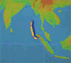
Cartographic animation
Those of us that remember the Indonesian tsunami might find this visualization interesting, if not fascinating. It certainly makes the scope more understandable.
http://upload.wikimedia.org/wikipedia/commons/1/12/2004_Indonesia_Tsunami_100px.gif
No comments:
Post a Comment
Newer Post
Older Post
Home
Subscribe to:
Post Comments (Atom)
No comments:
Post a Comment